Westport washout now open to one way traffic, defying early Caltrans forecast, 128 also reopening by 1 p.m, the current forecast says
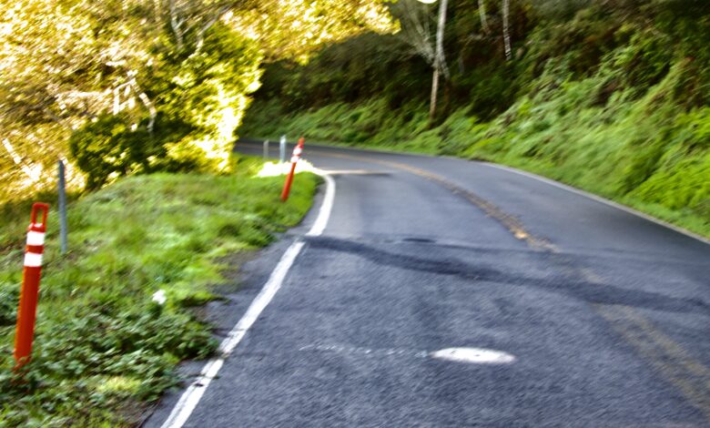
State Route 1 sinkhole opens just past Westport; Highway 128 closed at Navarro, possible reopening after noon. King tides, storms, and more rain are lining up this week. How much flooding will we see? Help us track it.
When we first started reporting this morning, there was only one way in and one way out of Fort Bragg. While we were on the road to check conditions, Caltrans posted an update: the Wages Creek washout north of Westport is now open to one lane of traffic. Conditions are changing by the hour.
We’re heading back out to investigate. Please use caution. At this point, we recommend using Highway 20 if you can — and avoiding Highway 1 north of Westport and Highway 128 until conditions stabilize.
Highway 128 at the Navarro River remained closed as of our last check at 9:30 a.m. With high tide just before noon, there is hope for an afternoon reopening, but nothing is guaranteed. Everything depends on river levels, tides, and how quickly the water recedes.
Winter has only just begun, and road conditions will remain unpredictable.
Rivers are full. Roads are closing, reopening, and closing again as water rises. And the king tides are on their way. When you combine king tides with storms and swollen rivers, coastal flooding becomes a real possibility.
The current forecast calls for rain Tuesday, Wednesday, and Thursday. After that, the question is whether the storms keep coming. If they do, rising tides could trigger more washouts and river‑based flooding across the region.
How much flooding? Right now, we have no idea. And is MendoReady actually ready? It doesn’t look like it.
MendoReady is the county’s decorative disaster‑information website — full of general tips, brochures, and evergreen advice. But on Sunday night, when I went looking for current information, there was nothing. It was the same static material it always is. MendoReady feels like one of those racks of glossy pamphlets you find at the Chamber of Commerce: helpful in theory, but not when the river is rising and the roads are washing out.
The only real information anyone can get is by calling the County Roads Department — and Howard’s crews are out in force, doing the work, not sitting at desks updating websites. Whatever happened to disaster preparation and real‑time planning?
Yes, MendoReady offers solid general information, available 24/7. But that’s not what coastal residents need when storms stack up, king tides approach, and the forecasts start looking serious. We live by the ocean. We need specific, current, location‑based information about what’s coming — not a library of generic advice.
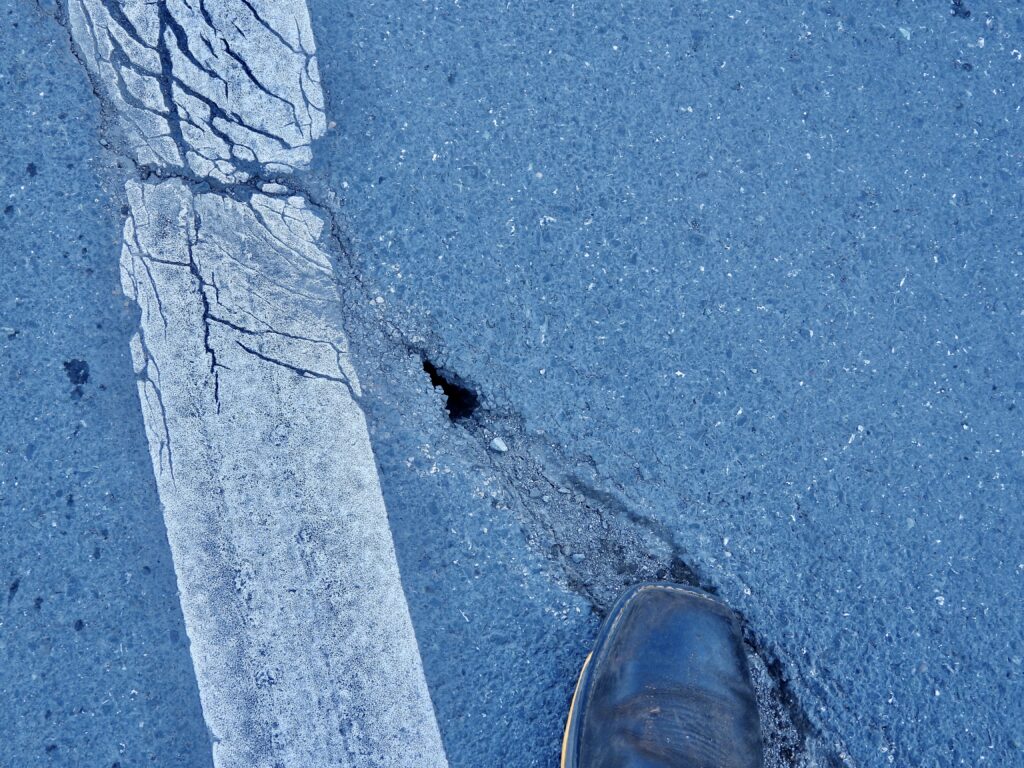
The only truly current information I could find didn’t come from MendoReady at all — it came from Caltrans press releases. Those updates announced that both the Navarro and the Garcia had flooded out State Route 1 and State Route 128. And now State Route 1 is closed exactly where Caltrans — and we (but never the other media) — have been warning it would.
“Call,” you say? Maybe someone out there has a full day to devote to that chore.
Trying to get real‑time information from the county is a chore of a chore of a chore. Calls go unanswered, messages aren’t returned, and the information you do get is skimpy at best. I find myself wishing for a computer model that could tell coastal residents what to expect when atmospheric rivers collide with king tides.
During the two tsunami events that thankfully turned out to be non‑events — but weren’t guaranteed to be — I received zero useful information from the county. I broadcast and wrote updates, but relied entirely on Berkeley professors and state resources. The City of Fort Bragg does a good job putting out sandbags, although I don’t need those myself.
If someone wants to help us track this down, we’re more than willing to dig deeper. Here’s what we know so far:
There’s a walloper of a high tide Monday at 11:29 a.m. That’s the window when coastal flooding is most likely. What we don’t yet know is the rain forecast for that exact hour.
Afternoon tides push to around 12:30 p.m. the next day, then advance roughly an hour later each day. The good news: the high tides get smaller and the tidal swing becomes less dramatic. The bad news: the morning tides grow larger as the week goes on.
In terms of tides alone, Christmas Day is the calmest, with the flattest pattern. But then a 4 a.m. tide on Dec. 26 builds into a New Year’s Day high over 7 feet just after 8 a.m. That’s a day and time to watch closely if you live along rivers or in low‑lying areas. Everything depends on rainfall and sea conditions.
The king tides continue to inch higher and arrive slightly later each day through January 3, and then they’re gone until December 2026. That doesn’t mean the monthly spring tides won’t cause trouble — it all depends on the alignment of rain, storm surge, and tide.
Although this is an oversimplification, we get two high tides and two low tides every day — or close to it. One is driven by the sun’s gravitational pull, stretching the ocean west and then letting it rebound east. Most of the time, the sun and moon tug against each other and things stay relatively balanced. But when they line up on the same side of the Earth, pulling in the same direction, we get the monthly highest tides, known as Spring Tides. The same effect happens when they’re on opposite sides but aligned — a synchronized tug‑of‑war that amplifies the extremes.
Once a year, the moon reaches its closest point to Earth in December, producing the moon‑driven king tides. The sun does the same in January. December was dry this year, so the king tides passed without much trouble. But when it’s wet and stormy — like right now — those high tides arrive and push the rivers back. And when the rivers are already angry and full, the only place left for the water to go is into your yard, your street, or your harbor.
Inland, there’s no ocean to contend with, but altitude becomes its own troublemaker. Higher elevations get much more rain — a simple fact, even if the exact mechanics are complicated. That extra rainfall becomes fast runoff, which then rushes into rivers whose deltas are already choked by storm surge, rain, and tide. It’s a perfect recipe for flooding.
So let’s watch the weather forecast closely and stay alert, prepared, and cautious. The county’s online information can help with general guidance, but it won’t tell you what’s happening minute‑by‑minute. If anyone out there has access to better real‑time data — or knows the secret path to getting hour‑by‑hour flood updates — please share.
Is there an app like Watch Duty for floods? Watch Duty and similar tools are imperfect, crowd‑sourced, and often overrated — robots built by volunteers instead of reporters — but they’re still incredibly useful during fires. Yet so much is lost when on‑the‑ground newspeople are replaced by automated feeds and crowd‑sourced blurbs.
I’m just not loving the automation of everything right now.
If you have information, insight, or want to help us track this, drop us a line at 707‑964‑6174 or email frankhartzell@gmail.com
