First of its kind tribal collective awaits resolution of “impossible” fix to State Route 1 before taking ownership of Blues Beach. You heard it here, first second, third..etc
Two of the biggest news stories of 2025 are happening at Blues Beach, at the same time, but are not related to each other. One is that unless a construction company whose motto is “We Deliver on the Impossible” can make good on their slogan, the state’s north-south Coastal artery could be severed, cutting off Fort Bragg from Westport.


The other is that the state is ending a half century of wild partying at Blues Beach by transferring control of the entire place to a first-of-its-kind tribal entity named Kai Poma. Together they show how centuries of manifest destiny are being tested by a belligerent mountain and how Kai Pomo is somewhat humorously, coming to rescue the environment and the fire department from the cowboys. There is no bigger story literally, going on right now and it’s not about politics.
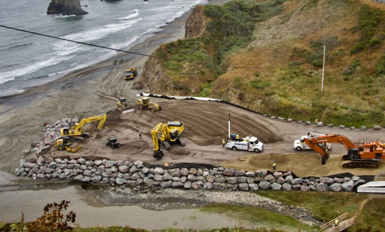
The biggest construction project on the Mendocino Coast has devoured a big chunk of Blues Beach and its entire parking lot. An elevated platform of gargantuan boulders, ranging from 20 feet off the beach to less than 10 feet off what used to be the parking lot is now in place.

Blues Beach is located about 12 miles north of Fort Bragg and 2 miles south of Westport.


The pad was built with maximum urgency and late night work at times. Workers from all over the state were unexpectedly called to Fort Bragg last week to join in the Myers and Sons Construction project directed by Caltrans. Caltrans had declared the project an emergency back in 2022, as the highway is threatened with being pushed off the cliff from the east and being undercut from the west
And something has apparently gotten worse very recently, that we don’t have full details on. For one thing, the pad was built quickly and without any announcement of a closure until this reporter contacted Caltrans, a month into the work.
Every day, the construction project waits for the tide to go out. Then, day or night, a flotilla of massive dump trucks takes boulders more than a quarter mile up the sandy beach. Then they stop and look, up, 250 feet up!, where a giant seawall is being built at the base to prevent a catastrophic collapse of State Route 1 above.

Even before it became a construction war zone, the end was near for the “Wild West” beach, campground, and whatever else people wanted to do there.
For now, and possibly forever, the free-for-all that has been Blues Beach for decades is over. For now, the reason is the construction emergency taking up the entire beach area. Only walkers that start out at a highway parking lot and proceed through a phalanx of cones will be able to get in while the huge project is going on. That’s at least until December. Those on site are saying it will take longer than that, more like October 2026. When that is done, the beach will never go back to the Wild West place it was, due to environmental degradation caused mostly by just a few very bad actors.

Back in the 1960s and 70s almost all beaches in California were open to driving and pretty much unregulated. But then, the environmental movement came along, pushed by flaming rivers back East, choking air pollution and dead bodies of water like the Hudson River and Lake Erie, the massive dieoff of eagles, pelicans and other large birds due to DDT and much more.
So by the turn of the millennium, most beaches from Mendocino County to the Mexican border were closed to car, truck and ATV traffic, huge overnight campfires, fireworks and the general party scene.
Blues Beach and Pismo State Beach down South were the last official driving beaches. Driving on remote Usal Beach in the far north of Mendocino County still happens, although it is technically illegal now.


It’s also still Ok in many Oregon towns.
The problem with Blues Beach was so many people crammed onto it because there were no others around and tourist visiting numbers increased.
Vehicle use, overnight fires and parties increased dramatically on the beach. Shorebirds, seals and most other wildlife were chased off the beach. So much so that the environmental document done for the quick construction of the pad had little to consider beyond thrush in the bushes and the scarce denizens of Chadbourne Creek.
The California Coastal Commission began demanding a solution.
Caltrans, the owner of the beach, was not responsive to demands that they regulate it better. The transportation agency said it was not equipped to own and operate a popular recreation area.
But indigenous people told the Coastal Commission about the destruction of sacred sites by all the increased partying.

So the beach, unwanted by Caltrans, was picked as a great spot for the state to give land back to the original owners.
One problem was that the Yuki people, the prime users of the beach for more than 10,000 years, were not in a position to take the beach, as they were largely chased off the Coast entirely by settlers.

But three Mendocino County Pomo Indian tribes, some of which include Yuki people as members, were willing to help. Those tribes had also used the still spectacular fishing and foraging grounds for millennia, as they migrated back and forth to the Coast, migrating back inland when ocean conditions and red tides made living off the bounty difficult.
The land was inhabited by Coastal Yuki and Yuki people for millennia. Anthropologists and linguists say the Yuki people had a language not related to other indigenous peoples and even distinct physical differences. Yuki mostly exists today on the Round Valley Indian Reservation.

So it had to be all three Pomo tribes. The state has been returning tens of thousands of acres to indigenous peoples all over California, but giving land to a collective wasn’t legal under land back, Sen McGuire told me back in 2021. The local tribes turned to the Hoopa Valley Tribe, which has gotten more than 100,000 acres of its ancestral lands around Hupa Mountain in Humboldt County back through a variety of methods ranging from purchases to land back. That tribe created Kai Poma under its laws.
Here is my scoop on the tribes getting this back in 2021.


State Sen. Mike McGuire wrote the bill, then Gov. Gavin Newsom signed it. But getting it done has been a difficult 4-year process. A first-of-its-kind non-profit named Kai Poma was formed, not by any of the three tribes but under the laws of the Hoopa Valley tribe in Humboldt County.
The California Coastal Commission and Kai Pomo negotiated for several years, resulting in
• The state reduced the 172 acres they originally promised would be given to the tribes down to 136 acres.
•The California Coastal Commission made transfer of the land to Kai Poma conditional on one key thing- Blues Beach must be kept closed by the tribes after dusk every day until dawn.
• All the documents about the transfer say that driving on the beach caused damage to the beach that made giving the land to the tribes necessary. But nowhere does it say that the tribes must or must not end driving on the beach. They are required to maintain the environmental integrity of the beach but the decision about driving on the beach is left up to the tribes.

•The state decided to keep control of the newly repaved vista point parking lot at Bruehel Point, but not the trails below, including a handicapped accessible trail with benches that, until Caltrans failed to maintain it, was unparalleled on the Coast. A handicapped person could go to an ocean bluff top bench and breathe and feel and hear the ocean like nowhere else, then go down a path to the south with benches along the trail.

Blues Beach had been the Coast’s anything-goes party place from the 1960s to this year. People camped on the beach, had fires, set off fireworks, and most of all drove every kind of vehicle imaginable on the beach, often getting stuck with dramatic and expensive tow truck rescues needed. Partiers set off a terrifying fire with illegal fireworks in June 2021 that threatened to set the entire area ablaze. Biological reports show that all the shorebirds, seals, and pretty much any other wildlife was long ago scared away, likely from all the cars on Blues Beach. So much so that there were very few environmental issues to consider when the gigantic pad was constructed.

For myself, I visited and photographed the beach and all the headlands hundreds of times, and usually got a kick out of seeing kids learning to ride safely with mom and dad right on the beach. They were almost always responsible. But I was often irked to death by the small number of absolute jerks that would do things like drive right in Chadbourne Creek, where a valiant effort is underway to restore steelhead and Coho salmon. I had mixed feelings about all this until I came upon a huge mess of illegal fireworks left behind on July 4. With the construction site less than 100 feet away, someone was shooting off hundreds of bottle rockets, M-80s and whatever else was in a big stinking firepit full of fireworks pollution, with wrappers blowing in all directions.

Idiots! Good riddance to all of us settlers!
“Visitors in 4-wheel vehicles often drive from the parking lot) out to and along the beach, and many get stuck in the intertidal zone and
require assistance in pulling vehicles out from the water. The longstanding and often inappropriate use of the Property has damaged cultural and natural resources. To rectify past damage and protect the area for the future (The Coastal Commission decided it must be managed, and the state picked the tribes to do it).”


The Coastal Commission approved the transfer and a permit, conditional on the completion of a management plan. The plan was completed, but has nothing about driving on the beach in it and is vague throughout. Caltrans told me that the permit was issued recently but that the land ownership transfer won’t happen until after the construction project is over.
So, what is happening with the construction?
It’s mind-boggling,and we are only getting a small part of the story. Officially, Caltrans has declared an emergency on top of an emergency. Blues Beach was ENTIRELY closed off or partly closed off for more than a month and nobody in the press asked any questions, because nobody in the press ever asks any questions.


But when I went and asked questions, it motivated Caltrans to issue a press release, which all the do-nothing media sites instantly published the press release, pretending they had a story. And this is important because there is more here, now buried by these bobble heads pretending to be journalists, not by the authorities themselves. Caltrans has just upped the stakes on what was already an emergency on State Route 1 between Fort Bragg and Westport, high above the north end of Blues Beach. (Another weird thing is that Caltrans didn’t give the north end of Blues Beach to the tribes, just the south end and despite mistakes apparently made by the state’s legal department, they also managed to give control of the entrance to Kai poma.)
For a decade, Caltrans has fought an unstable and soupy mountain. Now, work is being accelerated to try to take back the upper hand that Nature gained this winter.
An earthquake that shook the Mendocino Coast in December made things worse, especially as it came in the middle of the rainy season.
Something recent has obviously increased urgency.
This week, a call went out all over the state by Caltrans and Contractor Myers and Sons, calling all workers back to this emergency site.
As dark fell on Wednesday, big cranes were still working full speed to create a gigantic elevated platform where the Blues Beach parking lot once was and much of the beach itself. I have never seen so much construction on top of a beach.
Workers who had been as far away as San Diego and near the Oregon border were asked on Tuesday to hit the road to Fort Bragg. They were working overtime Wednesday as dusk was turning into night, along with a big crowd of others and two huge cranes.
Caltrans appears to have picked the right contractor. Myers’ motto is “We Deliver on the Impossible.”
Caltrans has quickly and quietly had Myers set up a huge pad on top of part of Blues Beach and the entire parking area. On Sunday morning at low tide, the dump trucks full of giant boulders came with all the drama of a heroic military operation.
Coming from the west, waves and wind have been creating more and more slides and collapses under cutting under the road, Caltrans says.
But that’s on the beach at the bottom and just one of the herculean challenges Caltrans and Myers face..

250 feet above the beach and the boulders, a 1,400-foot wide landslide meets the road and is slowly pushing everything west. Myers is up there too, and will need every inch of their motto to work. The moon landing was no more difficult, or so my Humboldt State Geology professor told me. His name was John Longshore, he developed the university’s degree program in Geology and taught, consulted, inspired and advised for over 40 years at Humboldt State.


Caltrans has been saying for more than a decade that this road is in peril. But could it be LOST?. That’s the $200 million question. Caltrans is spending that much to try to save it and more. I asked Caltrans spokesman Manny Machado if the northern artery of the Mendocino Coast could be snapped off at this weak point. The answer was not, “no” as it once would have been, which chilled me.
“At this time Caltrans will continue to address the emergency situation on this stretch of highway to keep it safe and open for the traveling public. We have been able to work with our resource agency partners, tribal partners and local stakeholders to keep this emergency project moving forward.”
What would we do if even Myers can’t “Deliver on the Impossible.” ? “If this section of Route 1 were to be closed, traffic would have to use an alternate route to access destinations to the south of the location which would be U.S.101 south or North to Route 20 to Route 1, or for destinations to the north of the location the traveling public would need to take Route 1 at Leggett over to the coast. This could result in a significant amount of out-of-the-way travel.”
Holy flying brontosauruses Batman! Such a failure would be unprecedented in modern California history. While State Route 1 has failed in Central California due to other belligerent landslides, there are practical ways around those and Highway 1 is mostly a scenic route, not an artery there.
The cost of repairing the Westport Landslide Complex on the north end of Blues Beach was estimated at $110 million in 2022 and that has clearly gone up since with the new problems and additional workers being brought in from around the state this week as the project, already an emergency, the emergency has had an emergency and has been raised up a notch as the problems have gotten worse.
If this project were somewhere with solid bedrock. Like Colorado or the East Coast’s Adirondacks, the fix would be quick and easy. But the California geology is fragmented by the West Coast being the knife’s edge of the continent. Millions of years of collisions between continental plates have turned bedrock into hills that are much gelatinous as solid.

Caltrans has already lost a similar battle at Confusion Hill. That mudslide inundated Highway 101 for a century became so intractable Caltrans had to build two giant bridges over the slide, at a cost of nearly 100 million. Geologists, engineers and construction companies with otherwise brass cojones took on the challenge of saving the highway, starting half a century ago. They all failed.
I got paid to sell the amazing story of all the king’s horses and all the king’s men being beaten by Mother Nature in a global construction magazine.
One of the bridges built to bypass Confusion Hill is higher off the Eel River than the deck of the Golden Gate is off the Bay and ocean.
When I was in college at Humboldt State my geology professor, the late John Longshore was hired as a consultant on a proposed road project and he told them it was impossible. They didn’t ever hire him again but were entangled in a multimillion-dollar effort to save that road.
He said hundreds of millions would be wasted because of the “we sent a man to the moon,” mentality. He predicted during our class that eventually, a few weak points on State Routes 1, 101 and 299 would see the total defeat of state engineers.

He said millions would be wasted because Americans simply cannot accept the notion that some things are impossible ,even when they are, especially when they seem much more mundane than moon landings.
20 years after graduation I called to congratulate him when his prediction came true on Highway 101 at Confusion Hill.
He said there would be more road failures as time went on and billions, not millions, would likely be wasted trying to win unwinnable engineering challenges.
Is that true here? We likely won’t find out till the money gets spent.
I always appreciate the professionalism of Mr. Machado and his willingness to explain the Caltrans viewpoint, but I found out way more talking to people and will continue to do so.
Caltrans says it will remove the pad at the end of the construction project and put Blues Beach back like it was. That makes zero sense. The parking lot was a huge mess of erosion and Volkswagen Bug sized potholes. The roads down to the beach were not fit for anything really but dune buggies’ and everybody trampled across Chadbourne Creek.

The Blues Beach acquisition by the tribes includes a largely untouched rocky area to the south of Blues Beach. The southern end of the beach and land for two linear miles of the Coast includes sacred sites as well as a bounty of mussels, clams and other sea life. Even if you are not indigenous, as I am not, there is no doubt this stretch is unlike any other place in its richness.
I took a bunch of photos down there when I wrote that original story on the deal and decided not to publish any of them, for fear of the cowboys once again robbing the treasures that should stay in the ocean and on its shores. I used to be a beachcomber and it’s legal but you shouldn’t. There is no place left where new generations can see what it looks like without us settlers!

The Coastal Commission’s summary of the Native viewpoint of the transfer:
“Through the colonization of this territory and the subsequent formation of the State of California, Native Americans were displaced from their rights of access and use in favor of the privatization of the land into the hands of migrant settlers. In the 1960s, those settlers profited from the sale of this land to the State of California, which purchased the Property to expand construction of Highway 1 and to provide a scenic viewshed for highway travelers. In contrast to the traditional use and care of the land by Native Americans, more recently, the general public has accessed this Property primarily for fishing and recreation, WITH LITTLE OR NO STEWARDSHIP BY THE STATE OF CALIFORNIA”
I put that in caps to show how one state agency evaluated the management of this place by another.

This story has many more fascinating elements to it. Mendocinocoast.news will continue to follow it and get answers to the following big questions
1.Can State Route 1 be saved or not?
2.Will there be driving on the beach ever again?

3. What do the tribes get out of this? They can already legally forage and fish on those pristine lands. How does ownership benefit them?
4. How will the tribes afford to maintain the land as the deal demands that public access always be free?
5. Why did the Coastal Commission insist that the California Coastal Conservancy oversee the tribe’s management of the property? The Coastal Conservancy is notorious both for its ability to get massive grants and also to spend that money on friendly out-of-town consultants, among other wastes on anybody but the locals.
6. Why did the state cut out 36 acres when they returned this land to the indigenous?
7. Is there a way that Yuki people could get some special recognition here, as this was their land for most of history, while the Pomo tribes shared it?

8. Why has the property not been transferred by now? The Coastal Commission recently approved a permit and issued it. Caltrans says the transfer of the land will happen when the emergency project is over. That seems very open-ended. Could this deal still fall apart?
9. The tribes have expressed an interest in projects to bring back coho salmon and steelhead to Chadbourne Creek. What is going on with restoration there?


